

Introduction
Guest contribution by Wesley Coates
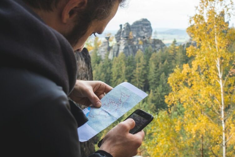
Hiking applications have become tools for enthusiasts, offering many features to enhance your hiking adventures. Before diving into applications, let’s explore what makes a hiking app valuable and why it is essential for your excursions.
What to Consider in a Hiking App
When choosing a hiking app, it’s essential to consider the following features.
Maps and Navigation: Accurate mapping and reliable navigation are aspects of any hiking app. Look for apps that provide maps, trail information, and the ability to function without an internet connection.
Trail Details: Comprehensive information about trails, including difficulty level, length, elevation gain, and user reviews, can help you select trails that align with your preferences and fitness level.
Offline Functionality: Since many hiking areas lack service, an offline app ensures you can access maps and information even when no network connection is available.
Safety Measures: Apps that offer real-time weather updates, emergency contact information, and the option to share your location with trusted contacts contribute to a hiking experience.
Community Engagement and Reviews: A user community, along with reviews, can provide insights into trail conditions, potential hazards, and overall user experiences.
Why Should You Consider Using Hiking Apps?
Hiking apps bring benefits to enrich your excursions, such as:
Navigation: Get real-time guidance to stay on track and reach your destination safely.
Trail Discovery: Find trails and outdoor spots that match your preferences and location.
Safety: Stay updated with weather conditions and emergency information and share your location for added protection during hikes.
Planning: Efficiently plan your hikes by accessing trail information, including difficulty levels and user reviews.
Community Engagement: Connect with hikers, share experiences, and tap into the wisdom of the hiking community.
App. Features
Now, let’s explore some of the top-notch hiking apps available. We’ll delve into their features that can elevate your hiking experience.
AllTrails
AllTrails is a hiking app that boasts a global trail database. Key features include:
- Vast Trail Collection: Choose from over 200,000 courses catering to hikers of all proficiency levels.
- Offline Maps: Download maps for usage in areas with no cellular connectivity.
- Trail Reviews and Photos: Get insights from hikers through their reviews, ratings, and photos to help you make informed decisions about the trails you’re interested in.
- Customizable Filters: Refine your trail options by applying filters based on difficulty level, trail length, and elevation gain. This way, you can find trails that match your preferences.
Gaia GPS
Gaia GPS is an app specially designed for hiking enthusiasts, backpackers, and those who love exploring off-road terrains. Here are some standout features it offers.
- Topographic Maps: Use maps to ensure accurate navigation and effective route planning during outdoor adventures.
- Sync Across Devices: Seamlessly synchronize your data across devices, including waypoints and maps. This ensures you have access to all your information wherever you go.
- Weather Overlays: Stay updated with real-time weather overlays so you can know the conditions and upcoming weather changes during your outdoor expeditions.
- Backcountry Navigation: Feel confident while venturing off the beaten path with reliable backcountry GPS features provided by Gaia GPS. These features will assist you in navigating through wilderness areas.
PeakVisor
PeakVisor is an app designed for mountain enthusiasts, offering augmented reality capabilities. Here are some key highlights of this app.
- Mountain Recognition: Utilize the power of your device’s camera to identify peaks in time as you explore your surroundings. This feature adds an element to enhance your mountain experiences.
- 3D Mountain Panorama: Immerse yourself in panoramas of breathtaking mountain landscapes that aid in trip planning. Visualize the terrain before embarking on your adventure for preparation.
- Offline Peak Identification: Enjoy the functionality of identifying peaks without an internet connection. This offline capability makes PeakVisor a valuable tool when exploring areas where internet access may be limited or unavailable.
- Global Coverage: Access information on mountains and peaks from around the world, making PeakVisor an essential companion for hikers who seek to explore extreme locations.
Google Maps
Google Maps, known for its navigation capabilities, has incorporated features specifically designed for hikers. These include the ability to discover hiking trails within the app itself, providing information for enthusiasts. Moreover, you can now download maps, ensuring you can navigate areas with poor or no connectivity. Additionally, Google Maps Street View allows you to explore trailheads and parking areas, which can be incredibly helpful when planning hiking trips.

FarOut
FarOut (previously known as Guthook Guides) focuses on long-distance hiking trails. It offers a range of features tailored specifically for thru-hikers embarking on journeys. You’ll find trail information that’s essential for these long-distance hikes. Furthermore, FarOut allows you to download trail maps and data, which is particularly crucial when navigating remote trail segments. Additionally, you can benefit from user-contributed updates and comments on the FarOuts platform to stay updated with the trail conditions.
Hiking Project
Hiking Project sets itself apart as a community-driven platform that emphasizes trail data and exploration. One of its standout features is the availability of trail maps that provide information such as elevation profiles and user reviews. Additionally, Hiking Project offers GPS navigation features to ensure route guidance while on the go. You can discover trails, and share your hiking experiences to contribute to the community.
Recreation.Gov
Recreation.Gov connects enthusiasts with a wide range of recreational activities, including hiking. Some notable features of the app include;
- Campsite Reservations: Besides hiking information, the app allows users to book campsites, enhancing their experience.
- Event Information: Stay current with outdoor activities in different recreational areas.
- Trail Details: Access information about trails, such as difficulty levels and amenities along the route.
National Park Service App
The National Park Service App is specifically designed for exploring the network of parks in the United States. Key features include;
- Park Information: Get details about each park, including trail maps and points of interest.
- Offline Maps: Download park maps for offline use, ensuring you have access to crucial information even in areas with limited connectivity.
- Alerts and Notifications: Receive timely updates on park conditions, closures, and other important announcements.
Seek by iNaturalist
Seek by iNaturalist is an app that caters to nature enthusiasts and wildlife lovers. Some standout features include;
- Species Identification: Utilize your device’s camera through this app to identify plants, animals, and fungi accurately.
- Discover New Learning Opportunities: Immerse yourself in the wonders of biodiversity with engaging content and exciting challenges.
- Uncover the Secrets of Nature: Elevate your hiking adventures by delving into the world of plants and animals you encounter along the trail.
Skyview Lite
Take your hikes to heights and indulge in a stargazing paradise.
- Experience Augmented Reality Sky Map
- Watch as your camera unveils stars, constellations, and celestial bodies in time.
- Night Mode for Stargazing: Switch to night mode for an optimized viewing experience during your treks.
- Time Travel Feature: Journey through moments of the night sky, helping you plan stargazing sessions on your hikes.
Cairn
Your Safety Companion for Solo Hikers and Outdoor Explorers
- Offline Maps and Live Tracking: Download maps for use and stay connected with real-time tracking to share your whereabouts with designated contacts.
- Emergency Alerts at Your Fingertips: Set a timer. If you don’t check in within the specified time, Cairn will notify your emergency contacts promptly.
- Cellular Coverage Maps Made Easy: Access user maps that display cellular coverage areas, ensuring communication while planning your routes.
Apple Fitness
Although Apple Fitness is not exclusively focused on hiking, it offers features that outdoor enthusiasts can benefit from:
- Tracking your activity: Utilize the app to keep track of your hiking adventures, capturing data such as distance covered, elevation gain, and calories burned.
- Integration with Health App: Sync your hiking data with the Health app, providing an overview of your fitness activities.
- Workout Plans: Gain access to guided workout plans specifically designed for activities, including hiking.

Komoot
Komoot is a versatile route planning and navigation app specially crafted for enthusiasts engaging in activities.
- Personalized Route Planning: Plan customized hiking routes based on your preferences, considering factors like distance, difficulty level, and points of interest you wish to explore.
- Offline Maps: Download detailed maps that can be accessed offline. This feature ensures navigation in areas where connectivity might be limited.
- Community Recommendations: Discover routes recommended by the Komoot community. This will help you make decisions when selecting trails.
ViewRanger
[Note: ViewRanger is now part of OutdoorActive]
ViewRanger combines detailed maps with an interactive social community to provide an enriching hiking experience.
- Top Quality Maps: Access detailed topographic maps that provide accurate terrain information for seamless navigation during your hikes.
- Route Recording: Record and share your hiking routes with the ViewRanger community. This allows you to showcase your adventures while also discovering routes from hikers.
- Augmented Reality Skyline: Utilize the augmented reality feature to quickly identify significant landmarks, such as peaks and lakes, during your hikes.
Mapy.cz
Mapy.cz is a mapping application focusing on activities, particularly hiking. It offers the convenience of downloading maps, ensuring access to navigation tools without an internet connection. With Mapy.cz you can also explore points of interest along your hiking routes, discovering landmarks, attractions and amenities. Additionally, the app allows you to plan custom routes with elevation profiles and detailed trail information.
FATMAP
FATMAP is an application designed specifically for outdoor enthusiasts like hikers and skiers. It provides 3D maps, allowing you to explore terrain, trails, and points of interest in depth. With FATMAP’s slope analysis feature, you can access information about slope angles to understand the landscape. The app also offers adventure planning capabilities to plan and share your expeditions, from hiking routes to backcountry excursions.
Outdooractive
Outdooractive is an application that caters to various outdoor activities, including hiking. Its multifunctional navigation feature allows users to utilize the app for hiking and cycling by providing detailed maps and navigation assistance. Outdooractive also offers route collections based on themes, difficulty levels, and regions, which allow users to explore curated sets of routes tailored to their preferences. Additionally, this app promotes community integration by enabling users to connect with enthusiasts, share experiences, and discover new routes through the community platform.
Recommendation
If you want to develop a hiking app tailored to your needs, visit our website today. Discover top-notch hiking app development services that cater to your unique requirements.
Regarding hiking apps, there are plenty of options, each with features that can enhance your outdoor adventures. Now, let’s summarize the elements and offer some guidance on how to pick the app for your hiking needs.
Summary of Key Features
Navigation and Maps:
Apps like AllTrails, Gaia GPS, Google Maps, and ViewRanger provide maps and reliable navigation features to help you plan and track your routes seamlessly.
Specialized Features:
If you’re interested in exploring nature and identifying flora and fauna, Seek by iNaturalist is a good choice. For a twist on your hikes, Skyview Lite allows you to identify stars and constellations.
Emergency Features:
Cairn offers safety features such as maps, tracking options, and emergency alerts. The National Park Service App provides information about park conditions and warnings.
Community and Social Integration:
Hiking Project and ViewRanger are community-driven platforms where users can share their experiences with hikers. Outdooractive and Komoot do not offer community recommendations or personalized route planning.
Fitness Tracking:
Apps like Apple Fitness and Komoot have fitness tracking features that let you closely monitor your hiking activities.
Visual Exploration:
For an experience with 3D maps and augmented reality features, PeakVisor or FATMAP are excellent choices.
Regarding using apps for activities, some options offer offline maps in areas with limited or no internet connectivity. Apps like AllTrails, Gaia GPS, and Mapy.cz provide this functionality. If you’re looking for an app that goes beyond hiking, Outdooractive is an excellent choice. It caters to activities.
To choose the app for your needs, consider what features you require.
Do you need navigation assistance, safety features, community interaction, or specialized exploration tools?
If you have preferences regarding trail difficulty, length, or elevation gain, apps like AllTrails with filters can be helpful.
For those who value community insights and sharing experiences with hikers, platforms like Hiking Project or ViewRanger may be more suitable. If safety is a priority for you as a solo hiker or someone who prioritizes safety features, Cairns emergency alerts and tracking capabilities can be valuable.
Nature enthusiasts who want to identify and learn about the flora and fauna they encounter on their hikes will find Seek by iNaturalist ideal. Fitness tracking features may be appealing to individuals who want to track their fitness progress while engaging in activity apps like Apple Fitness or Komoots.
If you enjoy immersive experiences during outdoor adventures, consider using apps such as PeakVisor or FATMAP. They offer 3D maps and augmented reality features that enhance your enjoyment.
No matter where your explorations take you globally, if you plan to explore trails outside your area, you can use apps such as Komoot, AllTrails, and Outdooractive. These apps offer a selection of options for outdoor enthusiasts.
Images: Unsplash/ Toomas Tartes, Patrick Schopflin, and Sebastien Goldberg.
Author Bio
Wesley Coates is a contributor at CampingWorld.com. When not busy at work, he enjoys taking his dogs for a stroll at the local park.